 |
Disturbance off the coast of Guinea Bissau/Southern Senegal (Sunday 12 UTC)
|
A new disturbance which is expected to be a named storm has been forecasted all week by global models. Yesterday, the system began to form and this morning the center of the event just West of Guinea Bissau. Model forecasts show the storm staying to the south of Cabo Verde but it requires careful monitoring. In particular, the rainbands and wind gust may cause flooding in San Tiago and its capital of Praia, and southern islands of Fogo and Brava. The genesis and intensification processes are the least known and in a data void region such as coastal West Africa there could be significant uncertainties. The system is expected to intensify over the next 24-72 hours and should become a tropical storm. For that reason, the system requires monitoring.
 |
| Expected Track of the Tropical Disturbance off the coast of Senegal |
|
TS Karen
Tropical Storm Karen formed yesterday and is just north of Trinidad and Tobago and due east of Grenada Last week the models picked up on this event as a possible tropical disturbance. By late last week, the models were no longer forecasting it to develop. TC Genesis forecast remains a challenge.
 |
| TS Karen, Sunday, September 22 at 1400 UTC |
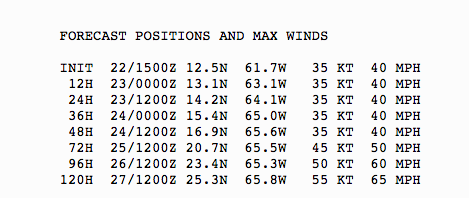
This is one of those tropical storms that is expected to be a weak system but could still bring heavy rains and gusty winds. TS Karen is expected to make a hard right and go north. Puerto Rico and the US Virgin Islands are in the path. Hopefully, the storm will remain a tropical storm but this event must be monitored if you live there. The National Hurricane Center has issued a Tropical Storm Watch for Puerto Rico and the US Virgin Islands. Winds are expected to be 40 MPH but notice, the intensity of the Karen is expected to increase over time. Most of the storms this year have been stronger than forecasted (Dorian for example) Sea Surface Temperatures are above normal by 1-2C which could fuel the intensification process. However, there is significant wind shear to the north of storm which should limit the intensification process. Flooding will be a threat no matter. There are indications in the long-term forecast that this storm may not go out to sea... we will see.
 |
Track of Tropical Storm, Sunday
|
 |
| NHC 11 AM Sunday, September 22nd Forecasted Positions of TS Karen |


No comments:
Post a Comment