Friday, September 27, 2019
Climate and Weather Distillery for Africa and the Africa Diaspora: Dry season brings and end to flooding season in Se...
Climate and Weather Distillery for Africa and the Africa Diaspora: Dry season brings and end to flooding season in Se...: Caption: Daily Rainfall in Senegal over the last 30 days. This has been the first week when significant rains did not fall in Seneg...
Dry season brings and end to flooding season in Senegal but not without consequences.
 |
| Caption: Daily Rainfall in Senegal over the last 30 days. |
 |
| Caption: Daily rainfall in Senegal over the last 90 days |
Then in mid-August, there was a poleward shift in the African Easterly Jet at 10000 feet and very wet conditions commenced with leading to flooding. This was also the start of a very active tropical cyclone season tropical disturbances Dorian through Lorenzo.
 |
| Caption: Satellite derived 30 day rain deficits (brown) or surplus (green) in mm
Satellite rainfall observations show that the 30 days of July 17-August 19 Senegal and Western Nigeria (circled in red) were very dry (left figure) but from August 19-17 September both regions were very wet.
What does it all mean??
Agriculture
Farmers in this type of weather regime continue to take losses. They cannot predict when to plant their seeds because the early rains are failing. Even if they have planted and crops survive to the main rainy period (August) then floods finish off the process. Because many cities have become urbanized, many people do not realize that these conditions promote food insecurity for rural residents but also for the country as a whole. It also promotes reduced income because of losses in rural areas where many do not have access to currency.
Infrastructure Damage
When flooding occurs it leads to property damages and losses of personal property that may not be insured. It causes damage to roads, roofs and building structures. and slows down the supply chain for the movement of goods. These losses are likely underestimated in many parts of West Africa.
Water Quality and Quantity
Flooding can lead to contamination of groundwater and in urban areas the overrunning of sewers can further worsen the problem. Large amounts of water are often sitting still for long periods of time because it cannot drain properly in urban areas and in other places will need to slowly evaporate.
Public Health: Malaria and other Water Borne Diseases
The sitting water caused by the heavy rains promote the breeding and spread of mosquitoes which may carry Malaria, Yellow Fever, and vector-borne diseases. Malaria will peak in October or November on average and is likely to be influenced by the heavy rains in August and September of this year.
The observed pattern of wetter conditions during the August and September which are linked to intense rainfall events are consistent with the published work using observations and models. The impacts are at the personal level which included fatalities in Senegal this year.
It looks like the end has come but in another week-10 days, I will be nearly 100% confident that the rains have really stopped.
As for tropical cyclones, the disturbances have now shifted towards the Guinea region. Any systems that can impact the US or Caribbean will come from lower latitudes of West Africa.
|
Sunday, September 22, 2019
Climate and Weather Distillery for Africa and the Africa Diaspora: A new Tropical Disturbance brewing off the coast o...
Climate and Weather Distillery for Africa and the Africa Diaspora: A new Tropical Disturbance brewing off the coast o...: Disturbance off the coast of Guinea Bissau/Southern Senegal (Sunday 12 UTC) A new disturbance which is expected to be a named storm...
Climate and Weather Distillery for Africa and the Africa Diaspora: Climate and Weather Distillery for Africa and the ...
Climate and Weather Distillery for Africa and the Africa Diaspora: Climate and Weather Distillery for Africa and the ...: Climate and Weather Distillery for Africa and the Africa Diaspora: Senegal being pounded again by rain after a rough ... : Caption: Dakar,...
A new Tropical Disturbance brewing off the coast of Senegal... Impacts possible in Southern Cabo Verde over the next 36 hours -- TS Karen in Caribbean
 |
| Disturbance off the coast of Guinea Bissau/Southern Senegal (Sunday 12 UTC) |
A new disturbance which is expected to be a named storm has been forecasted all week by global models. Yesterday, the system began to form and this morning the center of the event just West of Guinea Bissau. Model forecasts show the storm staying to the south of Cabo Verde but it requires careful monitoring. In particular, the rainbands and wind gust may cause flooding in San Tiago and its capital of Praia, and southern islands of Fogo and Brava. The genesis and intensification processes are the least known and in a data void region such as coastal West Africa there could be significant uncertainties. The system is expected to intensify over the next 24-72 hours and should become a tropical storm. For that reason, the system requires monitoring.
|

TS Karen
Tropical Storm Karen formed yesterday and is just north of Trinidad and Tobago and due east of Grenada Last week the models picked up on this event as a possible tropical disturbance. By late last week, the models were no longer forecasting it to develop. TC Genesis forecast remains a challenge.
 |
| TS Karen, Sunday, September 22 at 1400 UTC |
This is one of those tropical storms that is expected to be a weak system but could still bring heavy rains and gusty winds. TS Karen is expected to make a hard right and go north. Puerto Rico and the US Virgin Islands are in the path. Hopefully, the storm will remain a tropical storm but this event must be monitored if you live there. The National Hurricane Center has issued a Tropical Storm Watch for Puerto Rico and the US Virgin Islands. Winds are expected to be 40 MPH but notice, the intensity of the Karen is expected to increase over time. Most of the storms this year have been stronger than forecasted (Dorian for example) Sea Surface Temperatures are above normal by 1-2C which could fuel the intensification process. However, there is significant wind shear to the north of storm which should limit the intensification process. Flooding will be a threat no matter. There are indications in the long-term forecast that this storm may not go out to sea... we will see.
 |
| Track of Tropical Storm, Sunday |
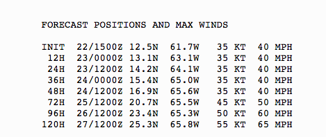 |
| NHC 11 AM Sunday, September 22nd Forecasted Positions of TS Karen |
Thursday, September 12, 2019
Climate and Weather Distillery for Africa and the Africa Diaspora: Senegal being pounded again by rain after a rough ...
Climate and Weather Distillery for Africa and the Africa Diaspora: Senegal being pounded again by rain after a rough ...: Caption: Dakar, Senegal Precipitation over the last 90 days This has been some month for rainfall in Senegal. Heavy rains have bee...
Senegal being pounded again by rain after a rough week of flooding and fatalities
 |
| Caption: Dakar, Senegal Precipitation over the last 90 days
This has been some month for rainfall in Senegal. Heavy rains have been falling over the last month as African Easterly Waves and Mesoscale Convective systems move across the area. The seasonal forecast for below-normal rain in this area but it has not been the case. Over the last 90 days, the conditions have moved from very dry to very wet. The heavy rain began around August 17 and has not let up. Prior to August, there were only two rain events. in July and no rain the prior month. Climate models predict this kind of behavior for a world with elevated greenhouse gases, n 2080 not now!
|
 |
| Caption: A Mesoscale Conveective system over Senegal (1900 EST), Thursday September 12 Tonight another MCS is impacting Senegal adding more hardship to the country. I spoke to a colleague (Habib) who told me that four people were confirmed dead from flooding this week around the Capital City of Dakar. He sent me a video showing a horse and its driver trying to survive in flooding waters. Horses are normally seen around the city carrying wood, metals or other materials right next to traffic. This is the nature of flash flooding, with water pooling and people, horses and cars being stuck.
Conditions continue to be optimal for heavy rains, and vigorous African Easterly Waves. Hopefully, some dry air will begin to creep in the desert later this week.
Malaria Season is coming For those of you not familiar with the Malaria season, the number of malaria cases will begin to rapidly rise in October and November. All of the flooding and standing water will increase the number of mosquitoes and malaria cases. But for the immediate future, the people of Senegal will need to remain ready to escape dangerous flash flooding situations on the roads and round their homes. |
Climate and Weather Distillery for Africa and the Africa Diaspora: SouthEast US Coast being impacted by a tropical cy...
Climate and Weather Distillery for Africa and the Africa Diaspora: SouthEast US Coast being impacted by a tropical cy...: NHC Tropical Weather outlook from Thursday, Sept 12 For the last few days, a trough of low pressure associated with an easterly wave ha...
SouthEast US Coast being impacted by a tropical cyclone???? -- Be Prepared and increase your level of awareness to local forecast and NHC
 |
| NHC Tropical Weather outlook from Thursday, Sept 12 |
For the last few days, a trough of low pressure associated with an easterly wave has been impacting the Bahamas with rain. This disturbance was forecast to move into the Gulf of Mexico. However, last night's 0000 model runs show a radical shift in the trajectory of the storm. The Canadian and European models show the storm moving up East Coast instead of entering into the Gulf. This is a potentially bad situation for those living in Georgia, Florida, South Carolina, North Carolina. We will have to see if the models continue this trend or not. The timing of such an event, if it occurred would be over the next 5 days. This means that there is ample time to prepare if such an event does occur. This morning's guidance shows that the trajectories are split between the Gulf of Mexico and the East Coast.
 |
| Thursday Morning Guidance |
The main point is that you should be storing water and non-perishables!! Please pay close attention to your local weather person and the National Hurricane Center if you live in Florida through North Carolina.
Regardless of this tropical disturbance, the waves coming off of Africa are active and that there is a higher likelihood of some tropical disturbances developing.
Be Vigilant during the Hurricane Season.
Tuesday, September 10, 2019
Climate and Weather Distillery for Africa and the Africa Diaspora: Active Wave Pattern across the Atlantic and back i...
Climate and Weather Distillery for Africa and the Africa Diaspora: Active Wave Pattern across the Atlantic and back i...: NHC Tropical Weather Advisory, September 10 This morning there are three active areas where tropical waves are present over the Western...
Active Wave Pattern across the Atlantic and back into West Africa
 |
| NHC Tropical Weather Advisory, September 10 |
This morning there are three active areas where tropical waves are present over the Western, Central and Eastern Atlantic.
1. Western Atlantic disturbance. Models are suggesting that the tropical wave just north of Haiti may develop in the Gulf of Mexico, but not all of the models agree. Any development would impact Louisiana or Texas over the next 4-5 days.
2. Central Atlantic Disturbance. This wave went across Cabo Verde a few days ago providing much-needed rain in the southern part of the country. It has gone through periods of organization but conditions are not currently favorable with strong wind shear to the north and west of the disturbance. However, the monsoon trough or a second wave is expected to develop in concert with this tropical disturbances. The Canadian and American models have disturbance impacting the Caribbean over the next week. Too early to tell how strong this disturbance will be if it forms at all. Be prepared in Puerto Rico and the Leeward Islands.
3. Eastern Atlantic Disturbance. This wave has been producing heavy rain over Senegal and The Gambia over the last 48 hours. It will likely give Cabo Verde rain today and tomorrow. This one needs to be watched in the coming days.
4. Over West Africa forecasted African Easterly Waves (AEWs) are lining up to emerge from the coast every 2-3 days. This could lead to flooding over land, but eventually one of these waves may become a tropical depression, storm or hurricane. The current environmental conditions remain favorable for strong AEWs (deep moisture and a strong African Easterly Jet that is located pretty far north). Coastal areas of West Africa and Cabo Verde should remain vigilant and be prepared to deal with unexpected changes in weather conditions.
Take away message:
1. Heavy rains and flooding possible in West Africa over the next 10 days
2. Tropical waves are very active and may have impacts as tropical cyclones downstream over Cabe Verde, the Caribbean, Gulf of Mexico or Eastern Atlantic Seaboard.
3. Don't drop your guard and be prepared.
Saturday, September 7, 2019
Climate and Weather Distillery for Africa and the Africa Diaspora: Climate Refugees in the future or Now? Don't wait...
Climate and Weather Distillery for Africa and the Africa Diaspora: Climate Refugees in the future or Now? Don't wait...: NASA MODIS image of Hurricane Dorian over the Bahamas - Sept 02, 2019 In the climate change community, people talk about climate refu...
Climate Refugees in the future or Now? Don't wait to adapt, do it now and locally!
 |
| NASA MODIS image of Hurricane Dorian over the Bahamas - Sept 02, 2019 |
In the climate change community, people talk about climate refugees in the future from drought, floods, and hazards. But the events over the last few years..really going back to hurricane Katrina tell us that for many people of color and low-income folks it is occurring. If you lose everything in a hurricane, family, home and if the community is destroyed how can you be resilient?
https://www.washingtonpost.com/video/world/with-bodies-still-in-the-streets-bahamians-look-for-a-way-out-of-marsh-harbour/2019/09/06/a040dce1-fb24-476e-989b-8ed8bf476261_video.html
The media covers the immediate timeframe of the storm, but what happens afterward to people and communities.. Do we know???? Do we know how people recover of if they ever recover, economically, mentally, physically or emotionally from these events? What are the stories of the recovery of communities?
Hurricane Irma destroyed 95% of Barbuda. Here is a rare story of the conditions 1 year later.
https://www.youtube.com/watch?v=B7mwreC5bCg
What is sad about this story, is that China is helping to build Barbuda. Where is the US???
The problem with all of this that politics are aways focused on national interest. How about doing the right thing?
Please don't take this in the wrong way but to solve a problem, you have to understand the problem. Many of the people in the Caribbean, South America, and the United States that live on vulnerable Islands or coastlines were externally displaced there through TransAtlantic Slavery. They were taken to islands or coastal regions that hurricane frequent and worked until they died or until emancipation occurred.
 |
| Centers where enslaved people taken from. https://www.slavevoyages.org/ |
 |
| Routes of enslaved people https://www.slavevoyages.org/ |
 |
| Location of where the enslaved taken to. https://www.slavevoyages.org/ |
http://www.slate.com/articles/life/the_history_of_american_slavery/2015/06/animated_interactive_of_the_history_of_the_atlantic_slave_trade.html
The future does not look promising with hurricanes expected to get stronger because of warming oceans from anthropogenic greenhouse gas emissions. Many of island and coastal communities provide only small inputs to the global inventory of carbon emissions.
In order for people to adapt, they will have to empower themselves. This means that communities should be working collectively on putting resources (food, water., generators, building micro-grids..) aside to deal with these events instead of waiting for aid. If the government supports this kind of effort, fine, if not a community has resources to help it get through the tough times after a land-falling hurricane. This works even for under-resourced communities where everyone can contribute to the storage of emergency supplies. This seems far fetched but could be a solution based on what we are currently observing.
This type of community building towards adaptation can happen in Puerto Rico, North Carolina, Barbuda, Cape Verde or Flordia. In addition, there should be an awareness of skillsets that are available for providing mental or physical assistance during the event and for rebuilding structures - carpenters, plumbers, electricians, masonry, roof repair after the event Of course, you need money to get back on the ground but it certainly helps to know that there are people in your own community that can pull together during the recovery phase.
At some point in near future, communities living in vulnerable zones will have to face the fact that they are not safe from hurricanes that are likely to increase in strength over time, and a rising sea level that will be at least 1 meter higher by 2100 if we don't back significantly on greenhouse gases. What to do then.. that will require some regional thinking. This all seems like a science fiction story but it is not because it is playing out now.
For now, please keep the people of the Bahamas in your thoughts and send what you can to help the people of the Bahamas. A list of organizations was published by the Washington Post.
https://www.washingtonpost.com/world/the_americas/hurricane-dorian-aid-how-to-donate-to-rescue-relief-and-recovery-in-the-bahamas/2019/09/05/903ba688-cff4-11e9-a620-0a91656d7db6_story.html
What are your thoughts? Wait for the government? Save your own family? Strengthen your community?
Wednesday, September 4, 2019
Climate and Weather Distillery for Africa and the Africa Diaspora: Round 1 Hurricane Florence, Round 2- Hurricane Dor...
Climate and Weather Distillery for Africa and the Africa Diaspora: Round 1 Hurricane Florence, Round 2- Hurricane Dor...: Hurricane Dorian on Wednesday 1026 PM EST (NOAA Satellite-geocolor) This evening Hurricane Dorian is bearing down on South Carolina...
Round 1 Hurricane Florence, Round 2- Hurricane Dorian.. Stay and fight or run to safety? Please think about running to a shelter.
 |
| Hurricane Dorian on Wednesday 1026 PM EST (NOAA Satellite-geocolor) |
This evening Hurricane Dorian is bearing down on South Carolina and North Carolina. A little more than a year ago, it was Hurricane Florence.
 |
| Hurricane Florence on September 11, 3 days before striking North Carolina |
Comparisons in Hurricanes :
Hurricane Florence -
Incredible damage in North Carolina and South Carolina from surge, flooding.
Highest winds 150 mph
Lowest Pressure 937 millibars
Landfall category 1
Hurricane Dorian -
Highest winds 185 mph
Lowest Pressure 910 mb
Potential US landfall (Cat 2-3)
Massive damage in the Bahamas
Hurricane Florence caused tremendous amounts of flooding in North Carolina. The storm surge went up the rivers causing flooding, the beaches and areas near the coastlines were devastated and heavy rains caused lots of flooding.
 |
| September 2018, Carolina road washed out near Wilmington |
Far away from the coast in Duplin Country, the Cape Fear River went over its banks causing a tremendous amount of damage. House after house experienced flooding in a county where people are not rich.
 |
| Duplin County near NC-41 just before Wallace (Sept 2018) |
In my opinion, Hurricane Dorian poses a greater risk than Florence. First, it has been strengthening all day as has been upgraded to a Category 3. It is also a big storm and reminds me of Hurricane Floyd. Many people have not evacuated because earlier today it was forecasted to be a Category 1. The models have been in disagreement with the satellite data, with the storm showing greater organization throughout the day. I call family in NC and told them to be ready and that this might be worst than last year. With Hurricane Florence, many people had a false sense of security because the storm was downgraded. You have to look at all of the hazards (flooding, surge...) and not just the winds..
Here are the things to bear in mind with Dorian if you live in Southeastern North Carolina or NE South Carolina.
Winds -- they will likely gust beyond hurricane force for a large part of the region from Thursday through Friday. Expect down trees and roof damage.
Rain.. Flash flooding is likely in many areas
River flooding from Storm Surge. If you live near the Cape Fear river, please consider staying in a shelter until Saturday. The river will reach FLOOD stage. I-40 was closed at Burgaw last year because the road was flooded.
Given that Round 2 is about to start FOCUS and make sure that
1. You have all of your electronics charged.
2. Make sure that you have gas.
3. Know where the local shelters are located.
4. Make sure that you have fresh water and foods for several days.
5. Touch base with all loved ones before tomorrow morning and let them know where you would go if you have to evacuate.
6. Get all of your prescriptions and important papers together and put them in a bag that you can take with you if you have to flee.
7. Don't drive across a flooded road.
8. Watch out for falling trees, debris, and electrical wires.
9. Make sure that you have cash...
10. If you live near the Cape Fear River or others... It may flood anytime over the next 1-3 days. Don't get lulled into thinking that it won't flood. Dorian's storm surge is going to push the water into North Carolina.
11. Trust your gut, if you don't feel secure, flee to a nearby shelter.
Here are the latest warnings from NWS Wilmington (11 PM)
Dorian Local Watch/Warning Statement/Advisory Number 47
National Weather Service Wilmington NC  AL052019
1103 PM EDT Wed Sep 4 2019

NCZ105-051115-
/O.CON.KILM.HU.W.1005.000000T0000Z-000000T0000Z/
Inland Pender-
1103 PM EDT Wed Sep 4 2019

...HURRICANE WARNING REMAINS IN EFFECT...

* LOCATIONS AFFECTED
    - Burgaw
    - Rocky Point

* WIND
    - LATEST LOCAL FORECAST: Equivalent Cat 1 Hurricane force wind
        - Peak Wind Forecast: 55-75 mph with gusts to 90 mph
        - Window for Tropical Storm force winds: Thursday morning
          until Friday afternoon
        - Window for Hurricane force winds: Thursday evening until
          early Friday morning

    - POTENTIAL THREAT TO LIFE AND PROPERTY: Potential for wind 74 to
      110 mph
        - The wind threat has remained nearly steady from the
          previous assessment.
        - PLAN: Plan for life-threatening wind of equivalent CAT 1 or
          2 hurricane force due to possible forecast changes in
          track, size, or intensity.
        - PREPARE: Remaining efforts to protect life and property
          should be urgently completed. Prepare for considerable wind
          damage.
        - ACT: Move to safe shelter before the wind becomes hazardous.

    - POTENTIAL IMPACTS: Extensive
        - Some structural damage is likely, with buildings receiving
          roof damage as well as window, door, and garage door
          failures. Mobile homes potentially suffering severe damage,
          with some destroyed. Damage may be enhanced by projectiles.
          Locations may be inaccessible or uninhabitable for some
          time after the storm passes.
        - Widespread large limbs will be down and many trees snapped
          or uprooted, along with fences and roadway signs blown over.
        - Roads will be blocked in many areas as a result of large
          debris, especially within urban or heavily wooded areas.
          Several bridges, causeways, and elevated roadways will
          likely become unsafe.
        - Widespread areas will suffer from power and communication
          outages.
        - Several poorly secured small craft may break from their
          moorings.

* STORM SURGE
    - LATEST LOCAL FORECAST: Localized storm surge possible
        - Peak Storm Surge Inundation: The potential for 1-3 feet
          above ground somewhere within surge prone areas
        - Window of concern: through early Friday evening

    - POTENTIAL THREAT TO LIFE AND PROPERTY: Potential for storm
      surge flooding greater than 1 foot above ground
        - The storm surge threat has increased from the previous
          assessment.
        - PLAN: Shelter against storm surge flooding greater than 1
          foot above ground.
        - PREPARE: All flood preparations should be complete. Expect
          flooding of low-lying roads and property.
        - ACT: Stay away from storm surge prone areas. Continue to
          follow the instructions of local officials.

    - POTENTIAL IMPACTS: Unfolding
        - Potential impacts from the main surge event are unfolding.

* FLOODING RAIN
    - LATEST LOCAL FORECAST: Flash Flood Watch is in effect
        - Peak Rainfall Amounts: Additional 6-10 inches, with locally
          higher amounts

    - POTENTIAL THREAT TO LIFE AND PROPERTY: Potential for major
      flooding rain
        - The flooding rain threat has remained nearly steady from
          the previous assessment.
        - PLAN: Emergency plans should include the potential for
          major flooding from heavy rain. Evacuations and rescues are
          likely.
        - PREPARE: Strongly consider protective actions, especially
          if you are in an area vulnerable to flooding.
        - ACT: Heed any flood watches and warnings. Failure to take
          action will likely result in serious injury or loss of life.

    - POTENTIAL IMPACTS: Extensive
        - Major flooding from rainfall may prompt evacuations and
          numerous rescues.
        - Rivers and streams may rapidly overflow their banks in
          multiple places. Creeks and ditches will flood and may
          contain strong currents.
        - Flood waters may enter many structures, and some may become
          uninhabitable. Some road scours or complete road failures
          will be possible, along with the potential for sinkholes.
          Many streets and parking lots may flood, and may be
          impacted by flowing water. Many road and low-lying bridge
          closures are possible with some weakened or washed away.
          Driving conditions will be dangerous.The delivery of
          drinking water and sewer services may be interrupted. Flood
          waters may be polluted and contain hazardous materials.

* TORNADO
    - LATEST LOCAL FORECAST:
        - Situation is somewhat favorable for tornadoes

    - POTENTIAL THREAT TO LIFE AND PROPERTY: Potential for a few
      tornadoes
        - The tornado threat has remained nearly steady from the
          previous assessment.
        - PLAN: Emergency plans should include the potential for a
          few tornadoes.
        - PREPARE: If your shelter is particularly vulnerable to
          tornadoes, prepare to relocate to safe shelter before
          hazardous weather arrives.
        - ACT: If a tornado warning is issued, be ready to shelter
          quickly.

    - POTENTIAL IMPACTS: Limited
        - The occurrence of isolated tornadoes can hinder the
          execution of emergency plans during tropical events.
        - A few places may experience tornado damage, along with
          power and communications disruptions.
        - Tornadoes can cause damage to trees, vehicles, boats, and
          buildings. Unsecured mobile homes and poorly constructed
          structures are particularly vulnerable.
Monday, September 2, 2019
Climate and Weather Distillery for Africa and the Africa Diaspora: A heightened level of concern across the entire At...
Climate and Weather Distillery for Africa and the Africa Diaspora: A heightened level of concern across the entire At...: Caption: NHC Tropical Weather Outlook Page, Labor Day 2019 From the coast of West Africa to the Gulf of Mexico, there are tropical dis...
A heightened level of concern across the entire Atlantic Ocean into the Gulf of Mexico
 |
| Caption: NHC Tropical Weather Outlook Page, Labor Day 2019 |
1. Hurricane Dorian is expected to move up the coast. I think most folks feel that it will remain off the coast, but the global and high-resolution hurricane models have uncertainty on the track. My gut tells me that some part of the SE coastline will experience hurricane conditions. Please be ready.
2. The tropical disturbance in the Gulf may develop into tropical depression before going into Mexico. It could still bring heavy rain.
3. A strong African Easterly Wave is forecasted to emerge off the coast over the next 48 hours and potentially form into a tropical depression soon after. These type of low latitude waves are the most dangerous in the extreme Eastern Atlantic and have the potential to intensify off the coast of Senegal. This would pose a threat to the population of Cabo Verde. This disturbance could also move downstream towards the Caribbean the following week. Stay Tuned. The Cabo Verde season is in high gear.
Climate and Weather Distillery for Africa and the Africa Diaspora: Dorian -- may be a storm for the ages
Climate and Weather Distillery for Africa and the Africa Diaspora: Dorian -- may be a storm for the ages: This is a story that I planned to post last Thursday when Dorian was a Category 2, but I did not have time. Last night the storm moved ve...
Dorian -- may be a storm for the ages
This is a story that I planned to post last Thursday when Dorian was a Category 2, but I did not have time. Last night the storm moved very slowly and has been stationary over the Bahamas and causing catastrophic damage. The precautions listed below have been extended to Georgia, South Carolina and North Carolina. I worry that people up the coast do not think that the storm has power to cause significant damage because it is not a category 5 storm. Think again and prepare!!
Thursday August 29th blog ....
Category 2 hurricane Dorian is making its way towards the Florida Coastline. The Miami Herald had these 15 items that you need to have in mind before the hurricane Watch is issued.
https://www.miamiherald.com/news/weather/hurricane/article32519892.html
▪Begin listening for storm updates or check National Hurricane Center updates online at www.nhc.noaa.gov. Bookmark MiamiHerald.com/storm
▪ Fill the car’s gas tank and keep it topped off. Make sure the battery is in good condition.
▪ Check your battery-powered equipment. A radio could be your only link with the outside world during and after a hurricane.
▪ Review your preparedness plan with your household.
▪ Pick two places for your family to meet: a spot outside your home in case of emergency, such as fire, and a place away from your neighborhood, in case you can’t return home.
▪ Establish an out-of-town phone number with family or friends to relay messages about your whereabouts after the storm.
▪ Refill prescriptions.
▪ Stock canned foods, soft drinks and water.
▪ Collect medical and property insurance papers, immunization records and medical records of anyone with special needs in a rugged, waterproof container. Include a few cherished mementos. If you evacuate to a shelter, take these items with you.
▪ If you are not in an evacuation zone, determine your “safe room’‘ or a room that is away from windows and has walls close together.
▪ Put shutters, window and door protection in place if instructed by local officials.
▪ Do not trim branches or limbs from trees. These could become dangerous missiles if picked up by the wind.
▪ Locate the turnoff valves for electricity, water and gas.
▪ Inspect and secure mobile home tie-downs.
Subscribe to:
Comments (Atom)
Police Justice, Climate Justice and Hurricane Laura - The perfect storm
Caption: Hurricane Laura on Wednesday Evening, August 26, 2020 It feels like the movie called "The Perfect Storm" because many...

-
 Caption: Hurricane Laura on Wednesday Evening, August 26, 2020 It feels like the movie called "The Perfect Storm" because many...
 -
 This year has been an extremely active tropical cyclone season for the Atlantic Basin. The next named storm is Laura. In comparison, Hurri...
 -
 Caption: 2000 UTC EUMETSAT Infrared images This evening things are looking up. The disturbance moved very fast towards Cabo Verde with...